Файл:1776 Rennell - Dury Wall Map of Bihar and Bengal, India - Geographicus - BaharBengal-dury-1776.jpg

Повна роздільність (9106 × 6000 пікселів, розмір файлу: 16,86 МБ, MIME-тип: image/jpeg)
| Відомості про цей файл містяться на Вікісховищі — централізованому сховищі вільних файлів мультимедіа для використання у проектах Фонду Вікімедіа. |
Опис файлу
| Назва |
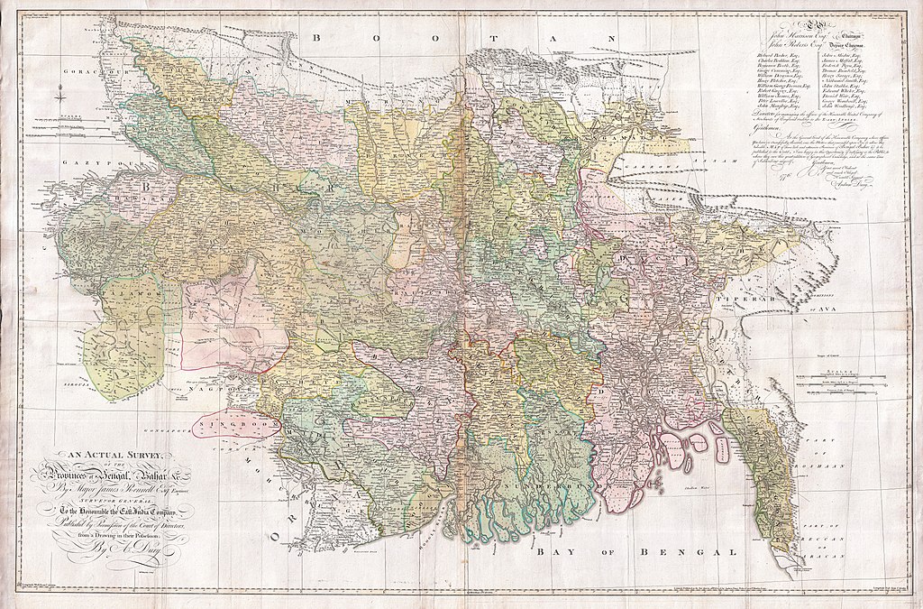
An Actual Survey, of the Provinces of Bengal, Bahar & c. by Major James Rennell Esq. Engineer to the Honorable the East India Company. Published by Permission of the Court of Directors from a Drawing in their Possession by A. Dury. |
|||||||||
| Опис |
English: An altogether spectacular wall sized map of those parts of Bengal and Bihar, India. Follows the course of the Ganges River from Varanasi (Benares) eastward to the Ganges Delta and the Bay of Bengal. Includes Varanasi (Benares), Dacca (Dahka, Bengladesh), and Patna among many other important Indian cities. Bounded on the north by the Himalaya Mountains and the border with Bhutan. One of the first accurate maps of the interior of India. Laid out from primary surveys done by James Rennell, the first modern cartographer to map the interior of India. Notes cities, markets, battlefields, fortresses, roads, rivers, offers political commentary, and features some geographical references. Elaborate title in the lower left quadrant. Upper right quadrant features a dedication and letter of thanks written by Andrew Dury, the publisher, to the board of the East India Company. This is the first edition of this rare map – 1776 – as published by Dury. Later editions were published by Sayer and Bennet and by Laurie and Whittle.
Another high quality digitisation is available at the David Rumsey Historical Map Collection: [1] This map was published by Laurie and Whittle, as mentioned in the description by Geographicus for the 1776 map, in 1794. Regions are demarcated in coloured outlines instead of filled colours. A higher quality digitisation than that of Geographicus. Contains parts that are missing at the central vertical fold in the Geographicus digitisation of the 1776 map. Viewable in online Flash viewer and downloadable in MrSID format. |
|||||||||
| Час створення | (dated) | |||||||||
| Джерело |
The Bengal Atlas ??, Rennell, James, (1779 first edition)
|
|||||||||
| Творець | ||||||||||
| Geotemporal data | ||||||||||
| Територіальне обмеження |
|
|||||||||
| Геоприв'язка | ||||||||||
| Archival data | ||||||||||
| Інвентарний номер |
Geographicus link: BaharBengal-dury-1776 |
|||||||||
| Розміри | висота: 39 дюймів (99 см); ширина: 59 дюймів (149,8 см) | |||||||||

|
Це зображення було оцінено згідно з критеріями значущих зображень і було визнано найбільш значущим зображенням в категорії Old maps of Bengal from 1776 by Major James Rennell. Ви можете переглянути його номінацію на сторінці Commons:Valued image candidates/1776 Rennell - Dury Wall Map of Bihar and Bengal, India - Geographicus - BaharBengal-dury-1776.jpg. |
Ліцензування
|
Ця робота перебуває у суспільному надбанні у країнах і територіях, де авторське право охороняється протягом життя автора та 100 років після того або менше. Ця робота перебуває у суспільному надбанні у Сполучених Штатах, оскільки вона була опублікована (або зареєстрована у U.S. Copyright Office) до 1 січня 1929 року. | |
| Цей файл визнано вільним від відомих обмежень з боку закону про авторські права, включаючи всі пов'язані і суміжні права. | |
Історія файлу
Клацніть на дату/час, щоб переглянути, як тоді виглядав файл.
| Дата/час | Мініатюра | Розмір об'єкта | Користувач | Коментар | |
|---|---|---|---|---|---|
| поточний | 08:39, 17 березня 2011 | | 9106 × 6000 (16,86 МБ) | BotMultichill | {{subst:User:Multichill/Geographicus |link=http://www.geographicus.com/P/AntiqueMap/BaharBengal-dury-1776 |product_name=1776 Rennell - Dury Wall Map of Bihar and Bengal, India |map_title=An Actual Survey, of the Provinces of Bengal, Bahar & c. by Major Ja |
Використання файлу
Така сторінка використовує цей файл:
Глобальне використання файлу
Цей файл використовують такі інші вікі:
- Використання в ar.wikipedia.org
- Використання в as.wikipedia.org
- Використання в azb.wikipedia.org
- Використання в bn.wikipedia.org
- Використання в bn.wikisource.org
- Використання в cs.wikipedia.org
- Використання в el.wikipedia.org
- Використання в en.wikipedia.org
- Використання в es.wikipedia.org
- Використання в fa.wikipedia.org
- Використання в fr.wikipedia.org
- Використання в hi.wikipedia.org
- Використання в ja.wikipedia.org
- Використання в ko.wikipedia.org
- Використання в ml.wikipedia.org
- Використання в mt.wikipedia.org
- Використання в ne.wikipedia.org
- Використання в nl.wikipedia.org
- Використання в pnb.wikipedia.org
- Використання в sa.wikipedia.org
Переглянути сторінку глобального використання цього файлу.