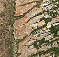
Файл:Central-eastern Brazil, by Copernicus Sentinel-2A satellite.jpg

Матеріал з Вікіпедії — вільної енциклопедії.
Перейти до навігації Перейти до пошуку

Повна роздільність(11 458 × 10 980 пікселів, розмір файлу: 94,42 МБ, MIME-тип: image/jpeg)

Wikimedia Commons logo Відомості про цей файл містяться на Вікісховищі — централізованому сховищі вільних файлів мультимедіа для використання у проектах Фонду Вікімедіа.

Опис файлу

Попередження У деяких браузерах можуть виникнути проблеми при перегляді цього зображення у повній роздільності: це зображення має дуже велику кількість пікселів і може завантажитись зі спотвореннями, або спричинити зависання браузера.
Опис
English: Central-eastern Brazil, by Copernicus Sentinel-2A satellite.

Here we can see a large, flat plateau blanked with fields benefiting from rich soils and an apparent abundance of water, before falling off into a green, hilly valley (left). The straight lines in the image are roads, such as the highway running in a nearly straight line from the centre-top to bottom of the image.

The area is particularly known for soybean production. The country’s soybean output has increased by more than 3000% since the 1970s, and Brazil is the second largest global producer of soybeans after the US.

Other crops in this area include corn, coffee and cotton.

A distinctive feature in this image is the circles – mainly at the centre. These shapes were created by a central-pivot irrigation system, where a long water pipe rotates around a well at the centre of each plot. The varying colours show different types of crop, or different stages of growth.

The two-satellite Sentinel-2 mission is designed to monitor changing lands, including crop type and health. While the first satellite has been in orbit since 2015, its Sentinel-2B twin was launched on 7 March. Together, the satellites will provide new images of Earth’s land surfaces every five days.
Час створення
Джерело http://www.esa.int/spaceinimages/Images/2017/04/Central-eastern_Brazil
Автор ESA / Copernicus Sentinel-2A

Featured зображення

Вікісховище

Це вибране зображення у Вікісховищі (Вибрані зображення) і є визнаним одним з найкращих зображень.

Якщо у вас є зображення подібної якості, яке може бути опубліковане під відповідною ліцензією авторського права, неодмінно завантажте його, виберіть ліцензію, і висуньте його.

Ліцензування

w:uk:Creative Commons
зазначення авторства поширення на тих же умовах
Цей файл розповсюджується під ліцензією Creative Commons Attribution-ShareAlike 3.0 IGO
Ви можете вільно:
  • ділитися – копіювати, поширювати і передавати твір
  • модифікувати – переробляти твір
При дотриманні таких умов:
  • зазначення авторства – Ви повинні вказати авторство, надати посилання на ліцензію і вказати, чи якісь зміни було внесено до оригінального твору. Ви можете зробити це в будь-який розсудливий спосіб, але так, щоб він жодним чином не натякав на те, наче ліцензіар підтримує Вас чи Ваш спосіб використання твору.
  • поширення на тих же умовах – Якщо ви змінюєте, перетворюєте або створюєте іншу похідну роботу на основі цього твору, ви можете поширювати отриманий у результаті твір тільки на умовах такої ж або сумісної ліцензії.
Цей файл, був спочатку опублікований на зовнішньому сайті http://www.esa.int/spaceinimages/Images/2017/04/Central-eastern_Brazil, був перевірений 6 травня 2017 перевіряючим Daphne Lantier, який підтвердив, що у ту дату файл був там доступний на умовах зазначеної ліцензії.
© This image contains data from a satellite in the Copernicus Programme, such as Sentinel-1, Sentinel-2 or Sentinel-3. Attribution is required when using this image.
Зазначення авторства: Contains modified Copernicus Sentinel data 2016

The use of Copernicus Sentinel Data is regulated under EU law (Commission Delegated Regulation (EU) No 1159/2013 and Regulation (EU) No 377/2014). Relevant excerpts:


Financial conditions

Free access shall be given to GMES dedicated data [...] made available through GMES dissemination platforms [...].

Conditions regarding use

Access to GMES dedicated data [...] shall be given for the purpose of the following use in so far as it is lawful:

  1. reproduction;
  2. distribution;
  3. communication to the public;
  4. adaptation, modification and combination with other data and information;
  5. any combination of points (a) to (d).

GMES dedicated data [...] may be used worldwide without limitations in time.

Conditions regarding information to be given by users
  1. When distributing or communicating GMES dedicated data [...] to the public, users shall inform the public of the source of that data and information.
  2. Users shall make sure not to convey the impression to the public that the user’s activities are officially endorsed by the Union.
  3. Where that data or information has been adapted or modified, the user shall clearly state this.
Absence of warranty

GMES dedicated data and GMES service information are provided to users without any express or implied warranty, including as regards quality and suitability for any purpose.

Підписи

Додайте однорядкове пояснення, що саме репрезентує цей файл

Об'єкти, показані на цьому файлі

зображує

99 007 576 байт

10 980 піксель

11 458 піксель

Історія файлу

Клацніть на дату/час, щоб переглянути, як тоді виглядав файл.

Дата/часМініатюраРозмір об'єктаКористувачКоментар
поточний10:45, 12 червня 2020Мініатюра для версії від 10:45, 12 червня 202011 458 × 10 980 (94,42 МБ)The RedBurnColor balance
22:03, 5 травня 2017Мініатюра для версії від 22:03, 5 травня 201711 458 × 10 980 (92,43 МБ)Yannc:User:Rillke/bigChunkedUpload.js: HR from TIFF, 98% compression
20:24, 5 травня 2017Мініатюра для версії від 20:24, 5 травня 20171920 × 1840 (3,84 МБ)YannTransferred from http://www.esa.int/var/esa/storage/images/esa_multimedia/images/2017/04/central-eastern_brazil/16900171-1-eng-GB/Central-eastern_Brazil.jpg

Така сторінка використовує цей файл:

Глобальне використання файлу

Цей файл використовують такі інші вікі:

Метадані