Файл:1794 Laurie and Whittle Wall Map of Russia - Geographicus - Russia-lauriewhittle-1794.jpg
Перейти до навігації
Перейти до пошуку

Розмір при попередньому перегляді: 800 × 313 пікселів. Інші роздільності: 320 × 125 пікселів | 640 × 251 пікселів | 1024 × 401 пікселів | 1280 × 501 пікселів | 2560 × 1003 пікселів | 6000 × 2350 пікселів.
Повна роздільність (6000 × 2350 пікселів, розмір файлу: 4,42 МБ, MIME-тип: image/jpeg)
| Відомості про цей файл містяться на Вікісховищі — централізованому сховищі вільних файлів мультимедіа для використання у проектах Фонду Вікімедіа. |
| Митець | ||||||
| Заголовок |
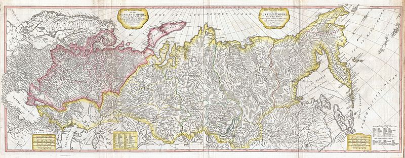
The European Part of the Russian Empire, from Maps Published by the Imperial Academy at St. Petersburg, with the New Provinces on the Black Sea. - The Asiatic Part of the Russian Empire from the Maps Published by the Imperial Academy of St. Petersburg, with the New Discoveries of Captian Cook & co. |
|||||
| Опис |
English: An rare and magnificently proportioned 1794 wall map of the Russian Empire by Laurie and Whittle. Extends from the North Sea and the Black Sea eastward as far as Siberia and the Behring Strait. Extends south to China and the Aral Sea and north to include the island of Nova Zembla and the Arctic. Color coded according to region with Russia in Europe toned in reds and pinks, and Russia in Asia in yellows and greens. This map is most interesting in its extreme eastern portions, which, when this map was drawn, had only recently been explored. The explorations of Vitus Behring are very much in evidence with regard to the form of Kamtschatka and the extreme northeast of Siberia. Shows variosu nautical routes from Okotskoi Ostrog, in Siberia, ccross the Sea of Okotsk to Kamtschatka and the Kuril Islands. Sakhalin is curiously divided into two separate islands. Hokkaido appears as Matmay or Atkis. Identifies Behring Island off the coast of Kamtschatka, where the great Arctic navigator ultimately met his doom. Published by Laurie and Whittle as plate no. 25 in the 1797 edition of Thomas Kitchin's General Atlas . |
|||||
| Час створення | 1794 (dated) | |||||
| Розміри | висота: 19 дюймів (48,2 см); ширина: 51 дюймів (129,5 см) | |||||
| Інвентарний номер |
Geographicus link: Russia-lauriewhittle-1794 |
|||||
| Джерело/Фотограф |
Kitchin, Thomas, Kitchin's General Atlas, describing the Whole Universe: being a complete collection of the most approved maps extant; corrected with the greatest care, and augmented from the last edition of D'Anville and Robert with many improvements by other eminent geographers, engraved on Sixty-Two plates, comprising Thirty Seven maps., Laurie & Whittle, London, 1797.
|
|||||
| Ліцензія (Повторне використання цього файлу) |
|
|||||
Історія файлу
Клацніть на дату/час, щоб переглянути, як тоді виглядав файл.
| Дата/час | Мініатюра | Розмір об'єкта | Користувач | Коментар | |
|---|---|---|---|---|---|
| поточний | 09:45, 23 березня 2011 | 6000 × 2350 (4,42 МБ) | BotMultichillT | {{subst:User:Multichill/Geographicus |link=http://www.geographicus.com/P/AntiqueMap/Russia-lauriewhittle-1794 |product_name=1794 Laurie and Whittle Wall Map of Russia |map_title=The European Part of the Russian Empire, from Maps Published by the Imperial |
Використання файлу
Така сторінка використовує цей файл: