Файл:Dasht-e Lut Iran 2006-02-28 ISS012-E-18779.jpg

Повна роздільність (1000 × 663 пікселів, розмір файлу: 237 КБ, MIME-тип: image/jpeg)
| Відомості про цей файл містяться на Вікісховищі — централізованому сховищі вільних файлів мультимедіа для використання у проектах Фонду Вікімедіа. |
Опис файлу
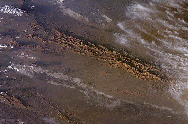
Winter in the Dasht-e-Lut Desert, eastern Iran
An International Space Station crew member took this striking photograph one evening in late February. The image takes advantage of the Sun’s low angle to reveal linear geological structures of the Iranian mountain range bordering the western edge of the basin known as Dasht-e-Lut. The range rises 1,818 meters (6,000 feet) above sea level and lies 750 kilometers (466 miles) north of the Persian Gulf. The convoluted appearance results from erosion of folded and faulted rocks—softer rocks erode away quickly, leaving more resistant rock to form linear ridges that are perpendicular to the direction of compression. While not a major oil-producing region like the Zagros Fold Belt to the southwest, the mountains of east-central Iran contain economically important deposits of copper and other metals.
Little vegetation can be seen from space in the arid interior basin of the Dasht-e-Lut. Iran is climatically part of the Afro-Asian belt of deserts that stretch from the Cape Verde islands off West Africa all the way to Mongolia near Beijing, China. The patchy, elongated, light-colored feature in the foreground (parallel to the mountain range) is the northernmost of the Dasht dry lakes that stretch southward 300 kilometers (186 miles). In near-tropical deserts, elevated areas capture most precipitation. Agricultural fields that depend on this precipitation appear as small dark patches in this image. They are located downslope, near the margin of the lake’s dry, salty soils.
Source
- http://earthobservatory.nasa.gov/Newsroom/NewImages/images.php3?img_id=17226 [1]
- http://eol.jsc.nasa.gov/scripts/sseop/photo.pl?mission=ISS012&roll=E&frame=18779
![[1]](http://earthobservatory.nasa.gov/Newsroom/NewImages/Images/ISS012-E-18779_lrg.jpg)
Ліцензування
| Цей файл перебуває у суспільному надбанні, оскільки він був створений NASA (Національним управлінням з аеронавтики і дослідження космічного простору). Згідно з політикою NASA стосовно авторського права, «матеріали NASA не захищаються авторським правом, якщо не вказано протилежне». (Див. Template:PD-USGov, сторінку політики NASA стосовно авторського права, або політику використання зображень JPL.) | ||
 |
Попередження:
|
Історія файлу
Клацніть на дату/час, щоб переглянути, як тоді виглядав файл.
| Дата/час | Мініатюра | Розмір об'єкта | Користувач | Коментар | |
|---|---|---|---|---|---|
| поточний | 05:52, 29 березня 2006 | | 1000 × 663 (237 КБ) | Pmsyyz | Dasht-e Lut, a desert in Iran |
Використання файлу
Така сторінка використовує цей файл:
Глобальне використання файлу
Цей файл використовують такі інші вікі:
- Використання в ar.wikipedia.org
- Використання в az.wikipedia.org
- Використання в bg.wikipedia.org
- Використання в bn.wikipedia.org
- Використання в bs.wikipedia.org
- Використання в ca.wikipedia.org
- Використання в ckb.wikipedia.org
- Використання в cs.wikipedia.org
- Використання в de.wikipedia.org
- Використання в el.wikipedia.org
- Використання в en.wikipedia.org
- Використання в es.wikipedia.org
- Використання в et.wikipedia.org
- Використання в eu.wikipedia.org
- Використання в fa.wikipedia.org
- Використання в fi.wikipedia.org
- Використання в fr.wikipedia.org
- Використання в gd.wikipedia.org
- Використання в he.wikipedia.org
- Використання в hu.wikipedia.org
- Використання в it.wikipedia.org
- Використання в ja.wikipedia.org
- Використання в ka.wikipedia.org
- Використання в kk.wikipedia.org
- Використання в kn.wikipedia.org
- Використання в ko.wikipedia.org
- Використання в ky.wikipedia.org
- Використання в lfn.wikipedia.org
- Використання в lt.wikipedia.org
- Використання в mk.wikipedia.org
- Використання в ml.wikipedia.org
- Використання в no.wikipedia.org
- Використання в pl.wikipedia.org
- Використання в pnb.wikipedia.org
- Використання в ps.wikipedia.org
- Використання в pt.wikipedia.org
Переглянути сторінку глобального використання цього файлу.